 Inglés UdeA - Cabezote - WCV(JSR 286)
Acciones
Inglés UdeA - EnlaceInteres - JSR(286)
Acciones


Signpost
Acciones
Generales
Factors of atmospheric pollution in the Aburrá Valley
Acciones
Factors of atmospheric pollution in the Aburrá Valley
By David Aguiar Gil, Professor at the Environmental School of the School of Engineering, and Coordinator / Researcher at the G-LIMA Laboratory
This article examines one of the Aburrá Valley’s greatest challenges: atmospheric pollution. It delves into the subregion's topographic characteristics the escalating demand for fossil fuels due to population growth, and the impact of forest fires as key contributing factors.
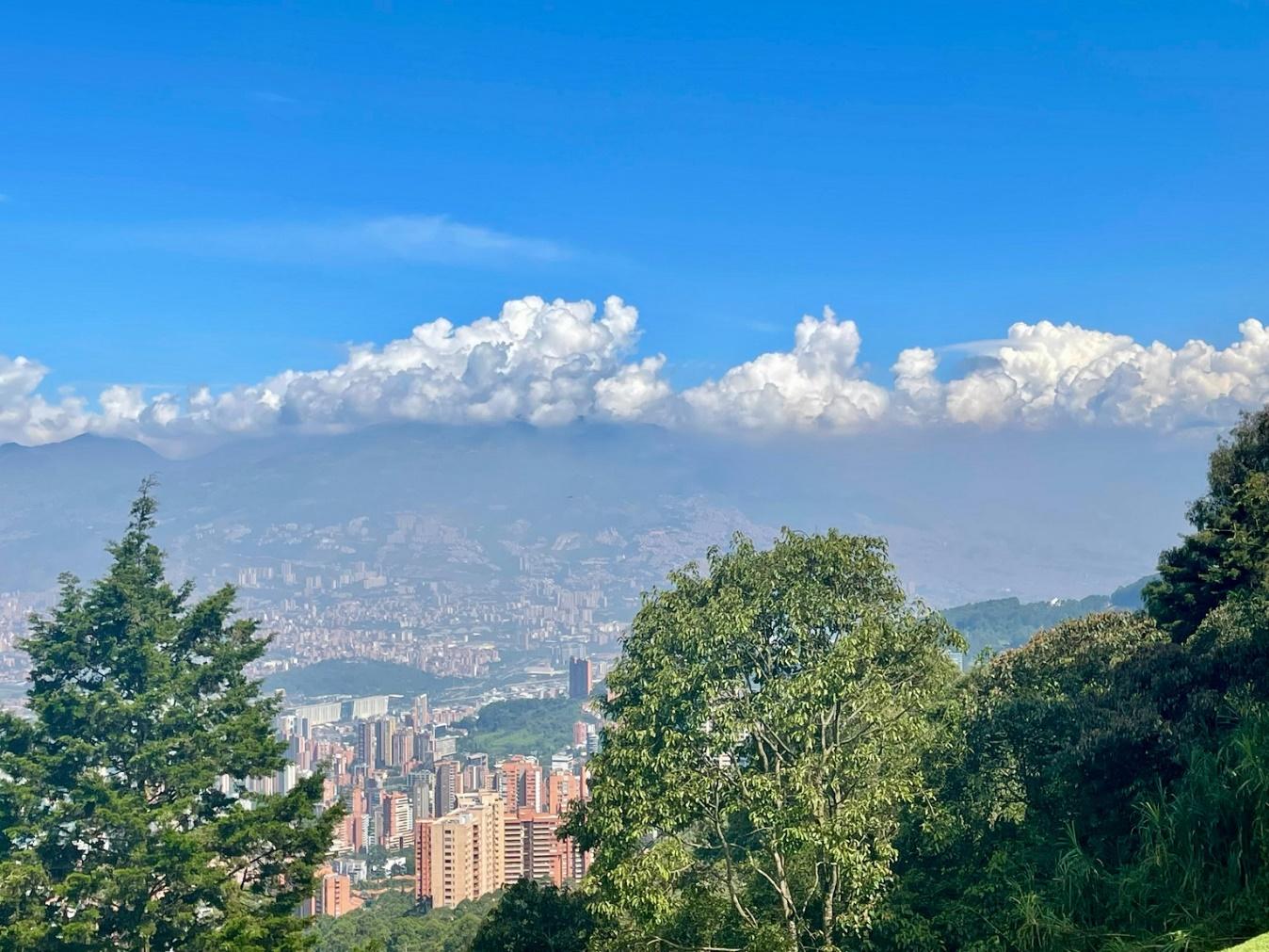
The Aburrá Valley is a sub-region with a diverse ecosystem and characterized by irregular topography, surrounded by numerous hill systems and forests. 95% of the territory, mostly hillsides, is urbanized and hosts multiple population settlements.
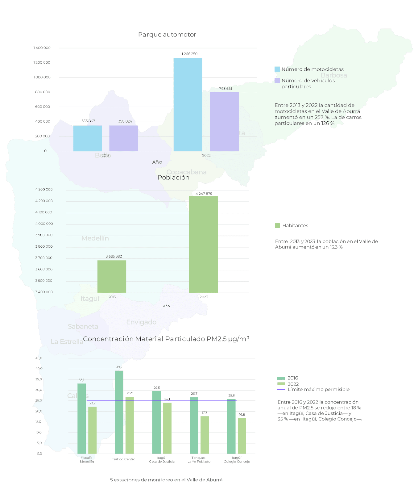
The National Administrative Department of Statistics (DANE) reported that by 2023, the Aburrá Valley was inhabited by 4,247,875 people, representing more than 60% of the department’s population. According to Comfenalco Antioquia, three out of every five residents of the Paisa region live in the Aburrá Valley.
These figures are significant, especially taking into account that the area comprises 10 municipalities, contributing to 70% of the departmental economy. However, it is noteworthy that this population increase represents a 15% rise compared to the figures recorded in 2013.
According to the environmental authority of this jurisdiction, the Aburrá Valley stands as the second-largest urban, economic, and population conglomerate in Colombia. Additionally, it serves as a migration epicenter, drawing people seeking academic and socioeconomic opportunities from across the country and around the globe.
Like many other regions, the territorial dynamics of the subregion are nuanced. For over 50 years, the area's attributes have combined with the high demand for fossil fuels, mainly in transportation and industry, leading to atmospheric pollution emerging as one of its greatest challenges. The biannual occurrence of pollution episodes is a notable example of this.
Contamination
In summary, air pollution in the Aburrá Valley arises from a blend of pollutant emissions and adverse weather conditions. The valley’s narrowness, surrounded by mountains that restricts wind circulation.
There, pollutants ascend with the air due to solar radiation heating the surface and the lower atmosphere. Once surpassing the height of the surrounding mountains, they are dispersed from the territory by the winds.
What changes occur during the transition from the dry season to the rainy season? When the weather shifts, low-altitude clouds form, and solar radiation decreases at the surface. Consequently, pollutants are unable to ascend and are dispersed by the winds.
Therefore, in the lower atmosphere, high concentrations of respirable particles such as Particulate Matter PM2.5, PM10, ozone (O3), volatile organic compounds (VOCs), and nitrogen oxides accumulate. These pollutants contribute to the management of atmospheric pollution episodes, prompting declarations from the Metropolitan Area of the Aburrá Valley (AMVA) between February and April and between September and November each year.
This alert signifies a period when air quality deteriorates, potentially posing risks to the environment and human health. Therefore, measures like restrictions, enhanced control, monitoring efforts, and recommendations for decision-makers and the general population are intensified during this time.
PM2.5, for example, is recognized as the pollutant with the most significant potential impact in Colombia. At a local level, its emissions stem mainly from transportation and industrial activities. These ultrafine particles are highly respirable and can transport carbon compounds, toxic metals, and organic compounds, increasing the risk of respiratory and cardiac diseases.
To analyze these episodes, it is necessary to examine the main sources.
Sources of contamination
The population increased in a sub-region covering an area of 1,165.5 km2. It escalates the demand for transportation, especially given the projections by DANE indicating that by 2022, 65% of the population in Aburrá Valley will be of working age, and 24% of the young population—between 14 and 28 years old—will be of educational age.
The Medellín Metro reports mobilizing around one million people daily. Additionally, the origin-destination survey published by AMVA last year specifies that between 2017 and 2023, there was a decrease in the use of this transport system, as well as the use of collective public transport and taxis.
What are people moving around on? The data reveals that 64 out of every 100 households in the Aburrá Valley own a motorcycle, while 16% own a car or bicycle. When analyzing a longer timeframe from 2013 to 2022, there has been an increase in the number of motorcycles (257%, rising from 353,867 to 1,266,250) and private cars (126%, climbing from 350,824 to 793,681).
In addition to the mentioned number and types of vehicles, there is also the diesel fleet, comprising buses, trucks, and dump trucks, generally old and significant contributors to pollution. In addition, the high congestion on roads increases travel times, increasing the emission of pollutants.
If you look at newer model vehicles, they exhibit inefficiencies, as much of their energy is lost in heat, and combustion pollutes much more during traffic jams.
When a highway is congested with cars, it becomes a source of linear pollution. The source is not solely the vehicles but the entire stretch of the road. It could be said that the frequent jams, known as “tacos” in the Aburrá Valley, exacerbate atmospheric pollution.
If we examine the data from the air quality stations in the Aburrá Valley (see infographic), we find that at the Trafico Centro station. It is situated at the Museo de Antioquia, where the annual limit of 25 µg/m3 of Particulate Matter PM2.5 per was exceeded in 2016 and 2022.
Other contaminants
Another representative pollutant in the Aburrá Valley is the informal burning of tires by certain residents to remove the wire, which they then sell as scrap metal. During atmospheric pollution episodes, carbon dioxide, sulfur, and other toxic substances emitted from these activities mix with particulate matter and linger in the air. Moreover, this process contributes to the Greenhouse Gas generation (GHGs).
On a larger scale, external phenomena like forest fires, which occur frequently during the dry season and peak in March in the northern region of South America, can emerge as the third relevant source of pollution in the Aburrá Valley. Emissions from these fires are transported to the region, leading to an elevation in the concentration of pollutants such as Particulate Matter PM2.5.
The Early Warning System of the Aburrá Valley (SIATA) highlights the additional influence of the ENSO phenomenon —Niño-Southern Oscillation— and its fluctuation between “El Niño” and “La Niña” phases. This variability can impact the frequency of forest fires and the emission of pollutants that could be transported to the Aburrá Valley. For instance, in 2023, the transition period from February to March coincided with the “La Niña” phenomenon, associated with high precipitation levels. During this time, a moderate number of vegetation fires occurred. This is the opposite of what happened in 2020, when “El Niño” conditions prevailed during the same period, leading to higher hot spots associated with fires.
The future
Drawing from the initial Pilot Plan Report conducted by urban planners Sert and Wiener in the late 1940s, columnist David Sierra explains in the Universo Centro newspaper that atmospheric pollution in the Aburrá Valley has been a problem for decades.
Due to the prevailing north-to-south direction of the winds, the industrial sector should have been located only on the southern banks of the Medellín River. However, the southwestern bank was developed as a mixed zone. Furthermore, as one of the first five cities in the country to establish air quality monitoring stations, Medellín provided crucial insights. Fifty years ago, it was discovered that between 1967 and 1974, Medellín alone exceeded the air pollution levels stipulated by the Pan American Health Organization (PAHO) on 267 occasions.
By then, the city had more than one million inhabitants, 60,000 cars were circulating, and mobility in the downtown area was already problematic.
Source: The Metropolitan Area of the Aburrá Valley (AMVA)
To a greater or lesser extent, the monitoring and restrictions on the discharge of polluting material into the atmosphere are as old as the stations in the country. So, what can be done to manage atmospheric pollution in the Aburrá Valley?
To a large extent, this stems from inefficient mobility. Therefore, an urgent measure is to reduce the number of vehicle trips per person, and we can achieve it by decreasing forced mobility for study or work.
Instruments like the Sustainable Business Mobility Plans (Plan MES), which must be implemented by organizations with more than 200 employees, contribute to this. In the case of the Universidad de Antioquia, this instrument encourages strategies such as teleworking, bicycle use, public transportation employment, and carpooling promotion.
When considering the environmental sustainability of the Aburrá Valley, it is important to consider its economic sustainability. This sub-region boasts a high business density, with 35.4 companies per 1,000 inhabitants by 2021, according to Antioquia Cómo Vamos. Additionally, it demonstrates a strong inclination towards services and manufacturing.
In conclusion
The existing issues within the territory have been identified, including specific periods with the highest probability of critical air pollution episodes occurring. Knowing this, it is important that educational institutions consider the implementation of strategies to reduce travel during these months. The increase in teleworking days and online classes are good measures.
It is equally vital to develop plans aimed at discouraging the utilization of private vehicles. The Metro system has already reached its operational capacity, necessitating the generation of alternatives to improve the system’s efficiency and its seamless integration with urban bus routes. Additionally, it is significant to strengthen the bicycle routes, ensuring they provide inclusive paths for all road users.
It is crucial to consider that existing regulations governing industrial emissions currently do not address pollutants such as PM2.5. Similarly, gas tests conducted on vehicles do not encompass PM2.5.
Finally, the occurrence of forest fires in the Amazon and the northern South American region is not a challenge that can be tackled at a local level. Rather, it requires coordinated efforts with Brazil, Bolivia, and Venezuela, as this phenomenon impacts the entire northern South American region.
Portal U de A - Redes Sociales - WCV(JSR 286)
Acciones
Inglés UdeA - Iconos Footer - WCV(JSR 286)
Acciones