 Inglés UdeA - Cabezote - WCV(JSR 286)
Acciones
Inglés UdeA - EnlaceInteres - JSR(286)
Acciones


Signpost
Acciones
Portal U de A
Droughts, heat, and fires in the Orinoquía
Acciones
Droughts, heat, and fires in the Orinoquía
Paola A. Arias and J. Alejandro Martínez, researchers at UdeA’s Environmental School and Faculty of Engineering
The Orinoquía, a region rich in biodiversity, features savannas and grasslands in its northernmost area. Fires frequently occur during the dry season. This article examines the meteorological conditions that drive fire activity in South America’s third-largest hydrographic basin.
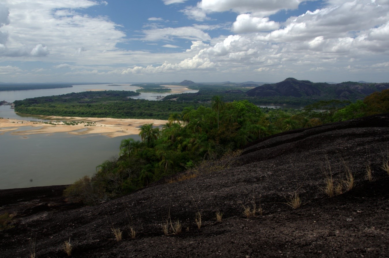
Landscape of the Orinoco River with a view of Magdalena Island. Photo by Luis Alejandro Bernal Romero.
Climate change is intensifying extreme weather events, including droughts. These begin with precipitation deficits (meteorological drought), which can deplete soil moisture (agricultural and ecological drought) and reduce surface runoff (hydrological drought). Droughts threaten water availability, impacting human populations and ecosystems. Their effects worsen when combined with warm extremes like heat waves or prolonged high temperatures. As global temperatures rise, these overlapping extremes are becoming more frequent. Scientific evidence shows that their increasing occurrence is magnifying their individual impacts worldwide.
The Orinoco is South America’s third-largest hydrographic basin, following the Amazon and Plata basins, covering eastern Colombia, much of Venezuela, and the Guyanas. It features savannas and grasslands in the north, transitioning to more lush vegetation in the south, where it meets the Amazon rainforest. The region’s natural and human systems are susceptible to dry extremes like droughts. A notable example is the 2014 Casanare drought, which led to severe water shortages and the death of numerous plants and animals. Both climate variability, including El Niño events, and climate change increase the likelihood of dry and warm events, amplifying the region’s vulnerability.
Our research project, funded by the Committee for the Development of Research at the Universidad de Antioquia (Codi), focused on analyzing the atmospheric conditions that drive the occurrence of these combined extremes and their impact on fire activity in this key region for Colombia, both ecologically and economically.
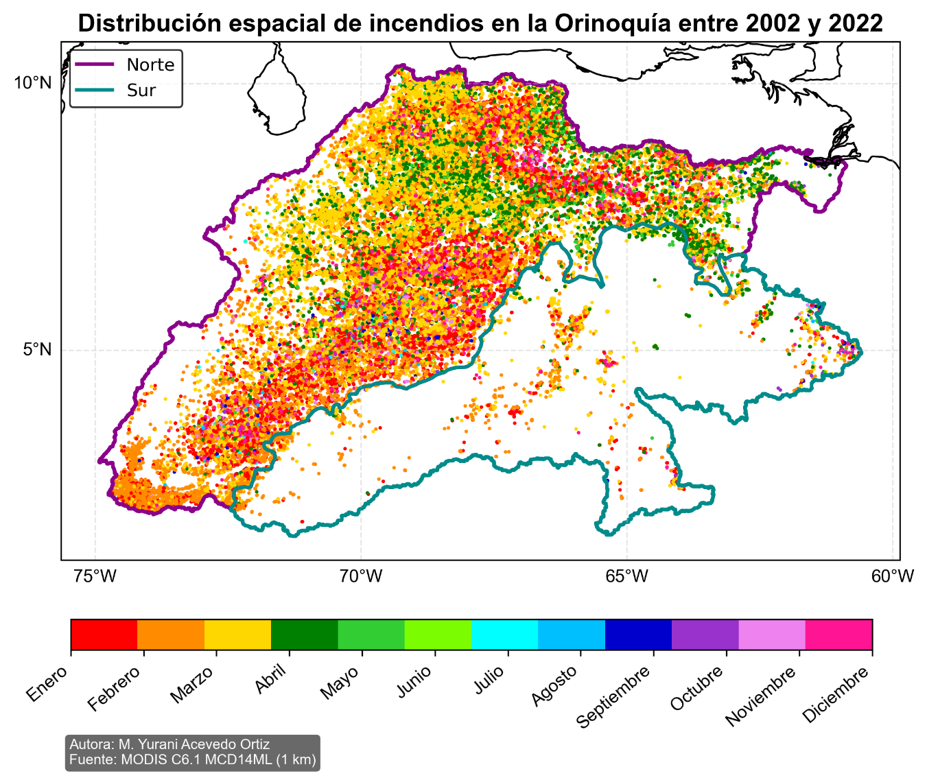
The graph displays the total number of fires in the Orinoco from 2002 to 2022. Each point’s color indicates the month in which the fire occurred.
What’s behind the declining rainfall and rising temperatures in the Orinoco?
Our results show that higher temperatures and lower rainfall in the Orinoco correlate with reduced cloud cover over the region. This decrease in cloud cover can result from either a lack of humid air or an influx of untypical dry air. In the case of the Orinoco, dry conditions often stem from anticyclones forming over the Atlantic. These vast air systems, stretching over thousands of kilometers, are most prominent at altitudes between 5,000 and 6,000 meters above sea level. The winds within these anticyclones rotate clockwise, moving air from northern regions toward the tropics. As this air travels considerable distances outside the tropics, it reaches the Orinoco with lower humidity or significantly reduced water vapor content.
The arrival of these winds can prevent clouds and rain from forming over the Orinoco. Specifically, when relative humidity is low at the altitudes where clouds typically form, vapor fails to condense easily into droplets and hydrometeors, reducing cloud formation, particularly those thick enough to produce rain. Moreover, if anticyclones bring air with lower water vapor, the amount of “fuel” necessary for cloud formation over the Orinoco decreases. Anticyclones over the Atlantic and Caribbean are natural occurrences, generally lasting from a few days to just over a week before dispersing. However, in some years, these systems can last longer or form consecutively with short intervals in between. Such conditions can lead to extended dry spells over the Orinoco, triggering droughts.
As cloud cover decreases over the Orinoco, more of the sun’s energy reaches the surface, which can lead to higher air temperatures. With increased solar radiation, more energy becomes available for evaporation from bodies of water, vegetation, and soil. It reduces the moisture in the soil, contributing to the onset or intensification of drought, leaving less water for rivers, ecosystems, and agriculture. When the lack of rainfall persists, the soil becomes so dry that evaporation slows, allowing solar radiation to more directly increase temperatures. As a result, prolonged dry periods can combine with extreme heat. In the past, these dry events in the Orinoco have lasted from several weeks to, in some cases, months. Eventually, atmospheric changes bring rain, and the surface enters a recovery phase, which can take a few weeks to months.
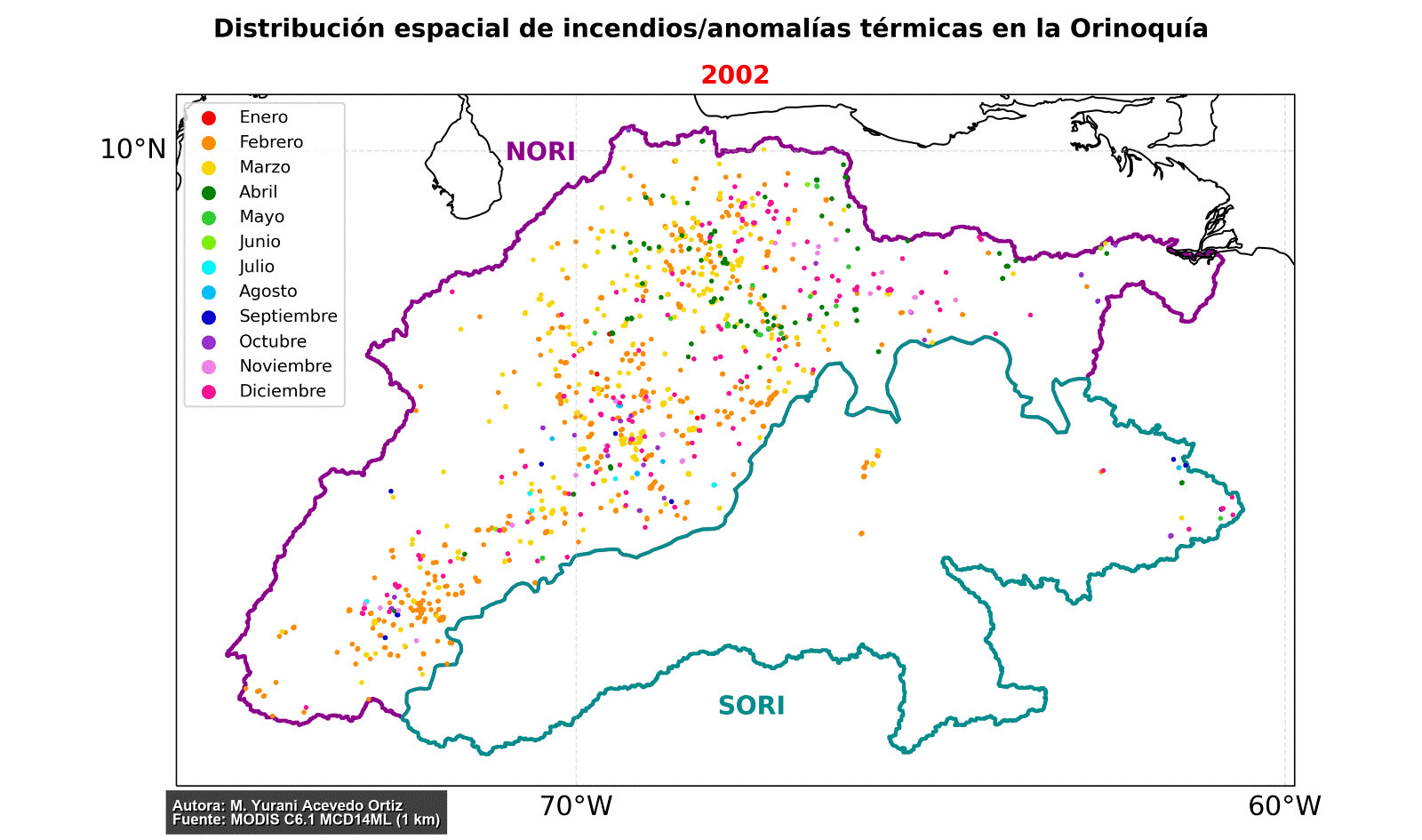
This animation illustrates the total number of active fires annually from 2002 to 2022. Each point’s color indicates the month the fire occurred. It helps identify the years with the highest number of fires in the region and shows that the fire season in the Orinoco generally spans from January to April.
How are dry and warm conditions linked to the occurrence of fires in the Orinoco?
Favorable meteorological conditions for fires, or fire meteorology, are characterized by high temperatures both in the atmosphere and on the surface (warm conditions), low moisture levels in the atmosphere and soil (dry conditions), and strong winds (windy conditions). When dry and warm extremes occur together, they create ideal fire conditions for ignition and spread, particularly in areas with flammable vegetation. In the northern Orinoco, with its vast grasslands and savannas, fires are common during the dry season (November to March), marked by significant precipitation seasonality. While most fires in the Orinoquía result from human activity, particularly agricultural practices, our research shows that dry and warm conditions lead to more frequent fires that cover larger areas. These conditions also lead to fires covering larger areas. It emphasizes the need to study meteorological conditions in regions where land use practices actively contribute to fire ignition, such as the Orinoquía. As climate change intensifies, it increases the likelihood of dry and warm extremes occurring together, making fires more likely to start quickly and spread widely, often beyond the control of those who initiate them.
*This project contributed to the completion of the thesis in Environmental Engineering by Alejandra Fernández Berrío and the Master’s in Environmental Engineering by Juliana Benjumea Garcés. It also involved valuable contributions from Marley Yurani Acevedo Ortiz, a student of the Master’s in Environmental Management, and Valeria Bedoya Pineda, a student of the Master’s in Environmental Engineering.
Portal U de A - Redes Sociales - WCV(JSR 286)
Acciones
Inglés UdeA - Iconos Footer - WCV(JSR 286)
Acciones